Opotaka
Phone
Website
Amenities
Suitable for Ages
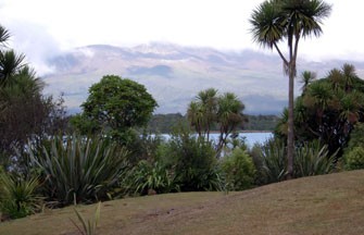
The Opotaka kainga (settlement) sat on the edge of Lake Rotoaira, which is south of Lake Taupo, on the Te Ponanga Saddle Road (State Highway 47), which runs between Turangi and National Park. It was one of a series of similar villages on the lake edge of Rotoaira.
Maori occupation of the Taupo region seems to have begun by the end of the 15th century, but much of the area remained unoccupied, as the area was not an easy place to produce food. In particular, the cold in the winter would have made kumara, a staple for Maori before European settlement, very difficult to grow. There were, however, settlements around Lake Taupo and at Lake Rotaira, as these places would have had better access to food resources such as birds, fish, and plants.
A number of Europeans visited Lake Rotoaira in the 1840s, and they have left us with descriptions of what life was like at the lake at that time. There were a number of settlements and cultivations on the edge of the lake. Motuopuhi pa, the largest settlement at the time, had strong defences and was probably used as a place of retreat in the case of attack for the people living in undefended settlements, including Opotaka.
Opotaka was surrounded by swamp on three sides, and by Lake Rotoaira on the other. Artefacts found at Opotaka confirm that it was probably occupied around the 1820s-1840s, when Maori and Europeans first had contact with each other in the area, and include both traditional artefacts such as obsidian and stone adzes, as well as metal tools.
Opotaka is important to local Ngati Tuwharetoa and Ngati Hikairo people and in 1981 was set aside as a Maori Reserve. Local Ngati Hikairo people have restored the site in recent years, and it is managed by Heritage New Zealand. You can see Lake Rotoaira from the site, as well as Motuopuhi Island, which sits opposite it. (Motuopuhi used be a peninsula, but is now an island because the level of the lake was raised by the Tongariro Power Scheme, submerging the link between the two). On Opotaka you can still see storage pits and the remains of the house sites.

Log in / Sign up
Continuing confirms your acceptance of our terms of service.
Post a comment