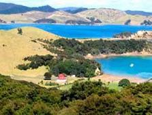
Urupukapuka Island
Website
Urupukapuka was described by du Fresne, in 1772, as containing villages fortified by palisades. It was occupied by Ngare Raumati before and after European settlement and was taken over by Ngapuhi in the early 19th century. Several kaainga were located on the island at this time. Late in the 19th century the island was developed for grazing. In 1927, the author Zane Grey began to use it as a base for game fishing and it subsequently became a world-famous fishing resort. The Crown acquired the island in 1970.
Urupukapuka Island is the largest island in the Bay of Islands and is historically important with a rich archaeological landscape. A total of 66 archaeological sites have already been identified on the 208ha island and there are many more on adjacent islets. Most date from hundreds of years of Maori settlement prior to European arrival. Sites relating to Maori include eight pa, village sites, gardens, and food storage and generally most are in good condition. The ‘Urupukapuka Island Archaeological walk’ allows visitors to view and interpret some of the island’s more dramatic archaeological sites.
Are you responsible for Urupukapuka Island?
You can claim this venue to manage this listing's details.

Past events at Urupukapuka Island
Log in / Sign up
Continuing confirms your acceptance of our terms of service.
Post a comment