October Green Drinks - Bi Monthly Event
363 SH 2, Clive, Hastings, Hawke's Bay / GisborneRestrictions
Listed by
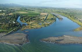
Along the coast between Awatoto and Haumoana, Waitangi links Tukituki, Ngaruroro and Tūtaekurī Rivers, as well as the Karamū Stream, Clive rivers and coastal reserves. The park covers an area of 300 ha along around 5km of a narrow strip of coastline. The estuary area was an early arrival site for both Māori and pākehā. The Star Compass, Ātea a Rangi, which stands right at the edge of the coast symbolises the navigational skills of early settlers at the regional park. This dramatic circle of pou (posts), stones and a whaharoa (gateway) has been developed by the Ātea a Rangi Educational Trust and installed through 2017. Local carvers created the pou, which represent the points of the compass. They worked with the Hawkes Bay Regional Council's open spaces team to enhance this important historical part of the coast.
Across the road from the star compass entry is the ‘Horseshoe Wetland’ which is home to many wading birds. Access is from the carpark, under the bridges and along the stop bank. A new wetland was constructed and finished in 2019. A partnership approach funded this construction - project partners, Te Wai Mauri Trust (which obtained Te Wai Māori funding), Ngāti Kahungunu Iwi Inc, Napier Port and Hawke’s Bay Regional Council who managed the project. The new 15-hectare wetland (currently un-named) aim is to provide even more habitat for fish, birds and whitebait spawning in this highly valuable biodiversity 'hot spot' area.
If interested in attending please RSVP no later than 10am on Tuesday 13th October to: greendrinks@environmentcentre.org.nz


Log in / Sign up
Continuing confirms your acceptance of our terms of service.
Post a comment