Greenstone and Caples Tracks
Website
The Caples and Greenstone Valleys are linked by McKellar Saddle, a sub-alpine pass, to make a moderate four to five day round trip.
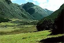
The Greenstone Valley is a wide, open valley with tussock flats and beech forest. In comparison, the Caples Valley is a narrower valley filled with forest interspersed with grassy clearings. Either of these tracks can be linked with the Routeburn Track, or they can be walked as a one way track starting or finishing at the Divide.
The grassy river flats of the Caples and Greenstone Valleys are private farmland. Please respect this, and stay on the tracks which follow the forest edge. Do not disturb stock. The forest is a Stewardship Area managed by the Department of Conservation. Fiordland National Park begins at the southern end of Lake McKellar.
The superb diversity of natural features in this area was recognised internationally with the establishment, in 1991 of the Te Wāhipounamu-South West New Zealand World Heritage Area. World Heritage status means this part of New Zealand has been recognised as being among the world's foremost natural landscapes.
Plan and prepare for a Great walk/Easy tramping track.
Time: 4 - 5 days
Image supplied by the Department of Conservation.
Are you responsible for Greenstone and Caples Tracks?
You can claim this venue to manage this listing's details.
Log in / Sign up
Continuing confirms your acceptance of our terms of service.
Post a comment